
Summary
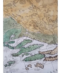
Coronelli Vincenzo Maria: Ristretto della Dalmazia diusa ne suoi Contadi alla serenissima republica di Venezia
Administrative map of southern Dalmatia from Šibenik to Bojana. Coroneli's administrative map of southern Dalmatia is one of the first thematic maps of Dalmatia that shows the administrative-territorial structure of Dalmatia after its annexation to the Republic of Venice. It existed independently, but also as an integral part of Coronelli's famous atlas "Isolario dell' Atlante Veneto" from 1696 and the so-called small island called "Mari, golfi, isole..." from around 1700
Biblos Newsletter
New titles, special copies and quiet recommendations from the antiquarian bookshop.