
Summary
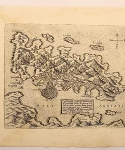
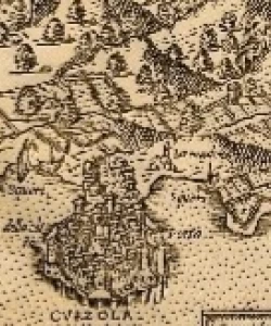
Giovanni Francesco Camocio: Curciola insula et citta nella Dalmatia - Island of Korčula
Copper engraving
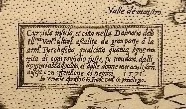
This is a panoramic map of the island of Korčula seen from a bird's eye view. The shape and outline of the island is unrecognizable and the town of Korčula is disproportionately enlarged. The ramparts and towers of the city are visible, and the three entrances to the city are indicated. The gardens and vineyards of the inhabitants of Korčula are visible in the hinterland of the fortified town. Part of the Pelješac peninsula is also visible.
CAMOCIO, Giovanni Francesco (Camocius, Camotius, Camotio; Giovani, Gioan) cartographer, publisher and map seller. In 1552, in Venice, he received privileges as a bookseller and publisher with a shop on S. Liu with the mark al segno della pyramida. He also had a copper engraving (cartographic) workshop in Venice where numerous maps and vedutes were made which were sold as individual sheets. He signed himself as a publisher, usually with apresso or apud G.F. Camocio cum privilegio. Camocio was often interested in Croatian regions, and he knew Croatia personally, and he also had his own topographers and cartographic data suppliers. In the period from 1560 to 1579, he published a large number of maps, and several of them showed Croatian areas. In 1563, he printed the map Novo dissegno della Dalmatia et Crovatia MDLXIII in Venice. In Venetia apresso Gioan Francesco Camocium al segno della Pyramide. It is one of the first printed regional maps of Croatia, which shows the part of the Croatian coast up to Šibenik with the interior of Croatia. Of these, 16 maps or views show the Croatian coast, namely the Adriatic Sea and Istria, views of Pula and Osor, maps of Zadar with its surroundings and Šibenik with its surroundings, views of Šibenik and Skradin, then panoramic maps of Trogir with its surroundings and Split with its surroundings, a cartographic-view view Makarska and its surroundings, a panoramic map of the Solina-Kliška area, a view of the city Hvar, maps of the islands of Hvar and Korčula and the water area Dubrovnik-Boka Kotorska.
Biblos Newsletter
New titles, special copies and quiet recommendations from the antiquarian bookshop.


