

Mercator Gerhard: Slavonia, Croatia, Bosnia cum Dalmatiae parte
€ 350,00
Free delivery in Croatia for orders over EUR 70
Basic information
- Author: Mercator Gerhard
- Publisher: -
- Availability: Available
- Condition: Odlično
- Code: 11062
Shipping options
GLS Croatia
5€
Delivery
0€
Personal collection at the antique store
0€
GLS parcel machine
3€
Payment methods
Pay on pickup
CorvusPay
By general payment / Virman / Internet banking
Cash on delivery
Slavonia, Croatia, Bosnia cum Dalmatiae parte
Mercator Gerhard
Summary
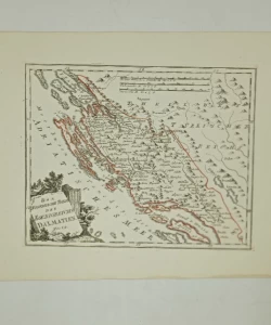
Gerhard Mercator: Slavonia, Croatia, Bosnia cum Dalmatiae / Map of Slavonia, Croatia, Bosnia and part of Dalmatia
Mercator's map of Slavonia, Croatia, Bosnia and part of Dalmatia, after it was first published in 1589, went through a series of editions in Dutch atlases. The editions differ only in the design of the cartouches. This edition was published in Blae's "Atlas Novus" from 1648. Like most Dutch maps of that time, this map also shows the Croatian lands in not entirely reliable medieval borders. Croatia's border with Bosnia was drawn slightly east of the river Una, the border of Dalmatia was moved far to the hinterland, so the whole of Herzegovina was under its wing. Zagreb was marked twice, once as Agram and the other time as Zagreb. The map is decorated with the coats of arms of the Republic of Venice, the Habsburg Monarchy and the Ottoman Empire. The title of the map is in the upper right corner of the map in an oval cartouche. The scale is expressed in Germanic and Italian miles.
Gerhard Kremer, better known as Gerhard Mercator (1512-1594), is, apart from Ortelius, the most famous Dutch cartographer. Unlike his Dutch contemporaries, he made his atlas maps himself. In general, he fought against the copying of other people's maps and the use of descriptive sources and stood up for the mathematical and geodetic basis of maps. In 1569, he published a map of the world in the new Mercator projection, which will also be his greatest merit in the development of cartography. Mercator's complete atlas was published in 1595 by his successors under the title "Atlas sive Cosmograficae". That atlas was preceded by several smaller collections of maps published during Mercator's lifetime. His maps of the New World, in which he outlined new discoveries, are particularly valuable. However, Mercator's interest was focused on Western Europe and the New World. For the Croatian lands, due to the circumstances of the war, he mainly uses numerous older sources, which is particularly evident in the drawn medieval borders and counties. His maps "Slavoniae, Croatiae, Bosniae cum Dalmatiae" and "Karstia, Carniola, Histria, Windorum Marchia" show a picture of the Croatian lands before the invasion of the Turks. His atlas saw about 40 editions.
Additional information
- Author: Mercator Gerhard
- Publisher: -
- Year of publication:1648
- Place of publication:Amsterdam
- Pages:-
- Dimensions:50x37.5 cm
- Script:Latinica
- Condition:Odlično
- Binding:Meki
You may also like


Recently viewed

Biblos Newsletter
For book lovers who enjoy finding the rare
New titles, special copies and quiet recommendations from the antiquarian bookshop.