
Von Reilly Franz Joseph: Der Landschaft Istrien: südlicher oder untere Theil
€ 180,00
Free delivery in Croatia for orders over EUR 70
Basic information
- Author: Von Reilly Franz Joseph
- Publisher: -
- Availability: Available
- Condition: Vrlo dobro
- Code: 71379
Shipping options
GLS Croatia
5€
Delivery
0€
Personal collection at the antique store
0€
GLS parcel machine
3€
Payment methods
Pay on pickup
CorvusPay
By general payment / Virman / Internet banking
Cash on delivery
Der Landschaft Istrien: südlicher oder untere Theil
Von Reilly Franz Joseph
Summary
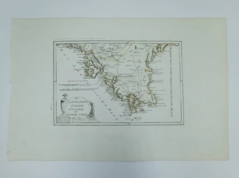
Franz Johann Joseph Von Reilly: Map of Southern Istria
This Reilly map is part of his tripartite map of Istria showing the southern part of the Istrian peninsula, from Krnica (Carnizza d'Arsa) and Saint Vitale (San Vitale) in the north to the southern headlands of Premantura in the south. The map shows the larger settlements of southern Istria, as well as the traffic connections between them. The number of toponyms in the inner part of Istria is significantly lower than in its coastal part. Special attention is paid to the numerous toponyms along the coast, especially the names of numerous Istrian bays. The title of the map is written in the lower left corner of the map on a cartouche in the form of an oval rock stone. The map scale is expressed in German and Italian miles. The map was published in Reilly's atlas called "Schauplatz der Welt Atlas" published in the period 1789-1791.
REILLY, FRANZ JOHANN JOSEPH VON
FRANZ JOHANN JOSEPH VON REILLY (1766-1820) Viennese cartographer, publisher and merchant. His most famous work is "Schauplatz der Welt Atlas" 1789-1791, " in which a large number of maps of Croatian countries were published. It was printed in Vienna, in the graphic workshop of Ignaz Albrecht. Other important works by Reilly are "Deutscher Atlas" from 1796 and "Atlas Univ." from 1799.
Additional information
- Author: Von Reilly Franz Joseph
- Publisher: -
- Year of publication:1791
- Place of publication:Beč
- Dimensions:47x31 cm
- Script:Latinica
- Condition:Vrlo dobro
- Binding:Meki
You may also like


Recently viewed
Biblos Newsletter
For book lovers who enjoy finding the rare
New titles, special copies and quiet recommendations from the antiquarian bookshop.