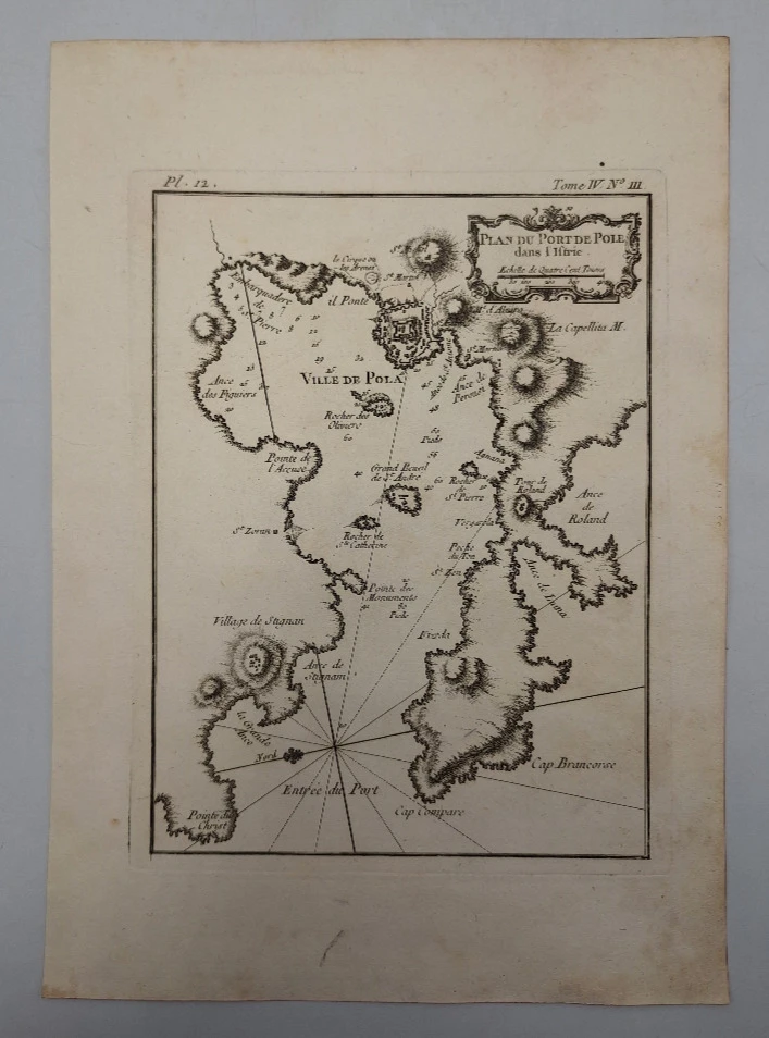

Bellin Jacques Nicolas: Plan du Port de Pole dans l'Istrie
€ 150,00
Free delivery in Croatia for orders over EUR 70
Basic information
- Author: Bellin Jacques Nicolas
- Publisher: -
- Availability: Available
- Condition: Odlično
- Code: 12934
Shipping options
GLS Croatia
5€
Delivery
0€
Personal collection at the antique store
0€
GLS parcel machine
3€
Payment methods
Pay on pickup
CorvusPay
By general payment / Virman / Internet banking
Cash on delivery
Plan du Port de Pole dans l'Istrie
Bellin Jacques Nicolas
Summary
Jacques Nicolas Bellin: Plan du Port de Pole dans l'Istrie
The map is from Le Petit atlas maritime: Tome IV. No 111.
The map shows the city of Pula (Pola) with the harbor and surroundings.
Jacques Nicolas Bellin (1703- Paris, 1772), maritime cartographer and hydrographer. He served for fifty years in the French Hydrographic Service where he was appointed the first 'Naval Engineer Hydrographer' and 'Royal Hydrographer'. He made hydrographic measurements of coasts, first of France, and then of all known coasts of the world. His immense work resulted in the creation of a large number of high-quality nautical charts that appeared in multiple editions at the end of the 18th century. In addition to several maritime atlases, he also created the atlas Description Geographique du Golfe de Venise et de la Morée in Paris in 1771, which is located in the University Library in Split. It contains sailing instructions, maps and plans of coasts, coastal towns, harbors and anchorages. In that atlas, he presented the Croatian regions in detail, and some of these maps are: Coste de Dalmatie entre Ragoniza et Stagno, Avec les Isles qui sontau Sud Savoir Brazza, Liesina, Curzola, Lissa, Lagosta, Melede, etc.; Carte des embouchures de la Riviere die Narenta. Et Oartie de son Cours jusqu Ciclut; Carte de l'Etat de Raguse et isles voisines. He was a member of the Royal Society in London.
Additional information
- Author: Bellin Jacques Nicolas
- Publisher: -
- Year of publication:1774
- Place of publication:Francuska
- Dimensions:24x32 cm
- Script:Latinica
- Condition:Odlično
- Binding:Meki
You may also like


Recently viewed


Biblos Newsletter
For book lovers who enjoy finding the rare
New titles, special copies and quiet recommendations from the antiquarian bookshop.