


Summary
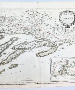
Pietro Santini: Nouvelle carte de la partie orientale de Dalmatie dressée sur les lieux.
Copper engraving
The map shows the eastern part of the Dalmatian coast, from today's Croatian islands of Hvar and Brač all the way to Kotor. The inset is a map of Boka Kotorska and most of the neighboring coast of present-day Montenegro. Ragusi (Dubrovnik) is marked on a map that is oriented towards the northeast by
Pietro Santini, Venetian cartographer and publisher who worked during the second half of the 18th century in Venice. He made several famous maps of Istria and Dalmatia. Pietro Santini's most famous work is "Atlas Universel", published in Venice in 1776 and 1783, and "Atlas Portatif" published in 1782.
Biblos Newsletter
New titles, special copies and quiet recommendations from the antiquarian bookshop.


