

Mortier Pierre: Plan trogirskih utvrda
€ 450,00
Free delivery in Croatia for orders over EUR 70
Basic information
- Author: Mortier Pierre
- Publisher: -
- Availability: Available
- Condition: Vrlo dobro
- Code: 11230
Shipping options
GLS Croatia
5€
Delivery
0€
Personal collection at the antique store
0€
GLS parcel machine
3€
Payment methods
Pay on pickup
CorvusPay
By general payment / Virman / Internet banking
Cash on delivery
Plan trogirskih utvrda
Mortier Pierre
Summary
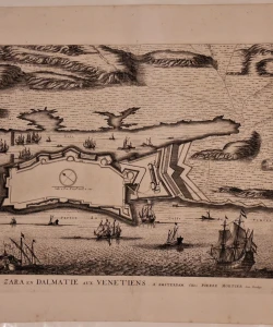
Pierre Mortier: Plan of the Trogir fortifications
The plan of the Trogir fortifications was published in Mortier's atlas “La Theater de la guerra”. This plan of Trogir appeared in circulation as early as 1695. Compared to the previously published views of Trogir (Coronelli), we see significant changes. Towards the mainland, the island on which Trogir is located was protected by three massive bastions. Fortress of St. Meanwhile, Marka is separated from the island by a sea trench. From the castle towards Čiovo, a long jetty with an opening for ships was made of stones. The port to the east was closed by a drawbridge towards the island of Čiovo. The urban structure of the city is not indicated. Namely, this is a classic fortification plan that shows only the defensive elements of the city. On Čiovo, right next to the bridge, you can see the settlement of the same name, which grew rapidly at that time. The Prince of Trogir had a court there. On the hill above the village, the people of Trogir built a small fort that defends the port of Trogir. The map is oriented to the south. The scale of the map is expressed in Venetian steps.
PIERRE MORTIER (1661-1711), a Dutch publisher and engraver who worked in Amsterdam during the second half of the 17th century and the beginning of the 18th century. Publisher of Sanson, Jaillot, de Fer and de Wit maps.
Additional information
- Author: Mortier Pierre
- Publisher: -
- Year of publication:1704
- Place of publication:Nizozemska
- Dimensions:63.5x54 cm
- Script:Latinica
- Condition:Vrlo dobro
You may also like


Biblos Newsletter
For book lovers who enjoy finding the rare
New titles, special copies and quiet recommendations from the antiquarian bookshop.