
Von Reilly Franz Joseph: Der Landschaft Istrien: mittlerre Theil
€ 180,00
Free delivery in Croatia for orders over EUR 70
Basic information
- Author: Von Reilly Franz Joseph
- Publisher: -
- Availability: Available
- Condition: Vrlo dobro
- Code: 71381
Shipping options
GLS Croatia
5€
Delivery
0€
Personal collection at the antique store
0€
GLS parcel machine
3€
Payment methods
Pay on pickup
CorvusPay
By general payment / Virman / Internet banking
Cash on delivery
Der Landschaft Istrien: mittlerre Theil
Von Reilly Franz Joseph
Summary
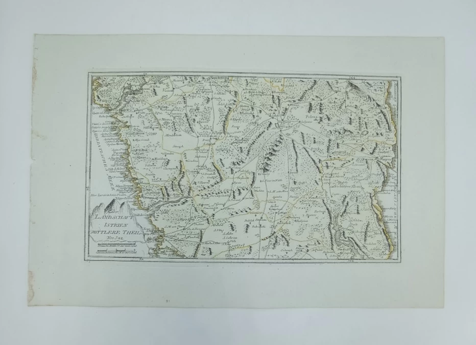
Franz Johann Joseph Von Reilly: Map of Central Istria
This map by Reilly is part of his tripartite map of Istria showing the central part of the Istrian peninsula, from Motovun in the north to Raše Bay with the fortress of Rakalj (Castelnuovo) in the south. In addition to settlements, road communications and the administrative structure in the area of Venetian Istria are marked. The relief is shown very schematically by a system of shaded molehills. Special attention is paid to the configuration of the coast and the depiction of the mouth of the Mirna (Quieto) and the Lim Channel (Kanal Lemo) and the bay of the Raša River (Hafen Arsa). The significantly larger number of toponyms along the coastal (Venetian) part of Istria compared to the small number of toponyms in the area of the central, Habsburg part of Istria (Pazin principality) clearly indicates that the author mainly used Venetian templates when creating this map. The title of the map is written in the lower left corner of the map on a cartouche in the shape of a rock. The map scale is expressed in German and Italian miles. The map was published in Reilly's atlas called "Schauplatz der Welt Atlas" published in the period 1789-1791.
REILLY, FRANZ JOHANN JOSEPH VON
FRANZ JOHANN JOSEPH VON REILLY (1766-1820) Viennese cartographer, publisher and merchant. His most famous work is "Schauplatz der Welt Atlas" 1789-1791, " in which a large number of maps of Croatian countries were published. It was printed in Vienna, in the graphic workshop of Ignaz Albrecht. Other important works by Reilly are "Deutscher Atlas" from 1796 and "Atlas Univ." from 1799.
Additional information
- Author: Von Reilly Franz Joseph
- Publisher: -
- Year of publication:1791
- Place of publication:Beč
- Dimensions:47x31 cm
- Script:Latinica
- Condition:Vrlo dobro
- Binding:Meki
You may also like


Recently viewed

Biblos Newsletter
For book lovers who enjoy finding the rare
New titles, special copies and quiet recommendations from the antiquarian bookshop.