
Von Reilly Franz Joseph: Der Landschaft Istrien: Noerdlicher oder Obere Theil
€ 180,00
Free delivery in Croatia for orders over EUR 70
Basic information
- Author: Von Reilly Franz Joseph
- Publisher: -
- Availability: Available
- Condition: Vrlo dobro
- Code: 71380
Shipping options
GLS Croatia
5€
Delivery
0€
Personal collection at the antique store
0€
GLS parcel machine
3€
Payment methods
Pay on pickup
CorvusPay
By general payment / Virman / Internet banking
Cash on delivery
Der Landschaft Istrien: Noerdlicher oder Obere Theil
Von Reilly Franz Joseph
Summary
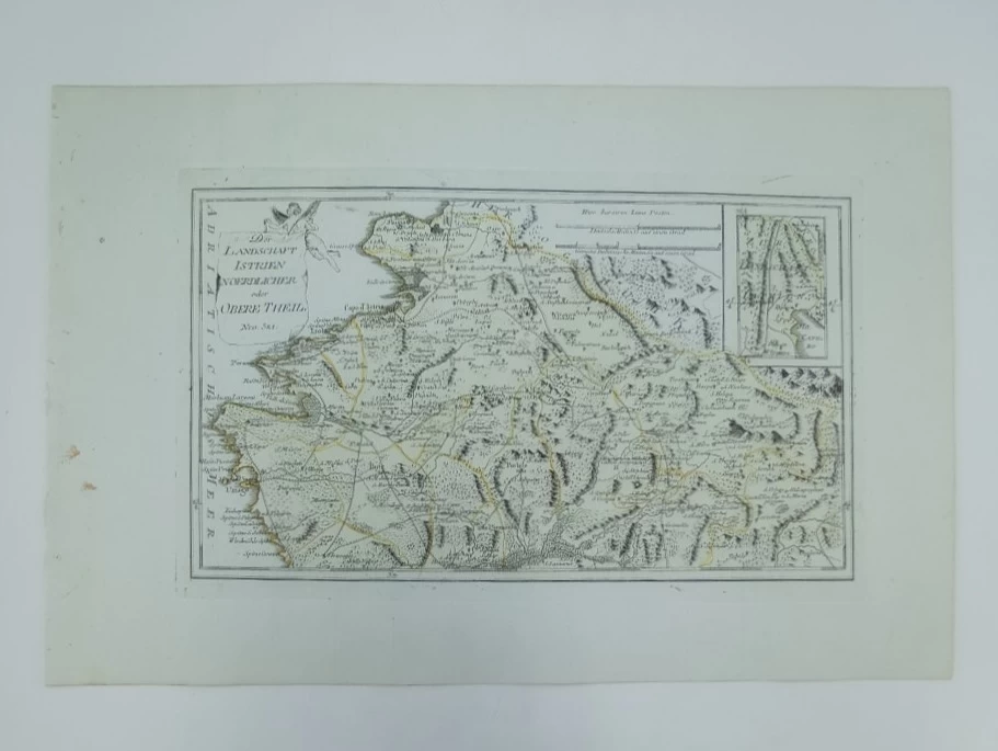
Franz Johann Joseph Von Reilly: Map of Northern Istria
This map is part of a three-part map of Istria that was published in Reilly's atlas called "Schauplatz der Welt Atlas" published in the period 1789-1791. This Reilly map shows the northern part of Istria from Muggia (Italy) in the north to Završje (Piemonte) in the south. Special attention is paid to the representation of roads (postal routes) and the administrative structure of Istria (pink lines). Particularly impressive is the depiction of the valley of the Mirna River with its tributaries and a wide swampy zone, as well as the depiction of the mouth of the Dragonja River. On the additional map in the upper right corner, the southeastern part of Istria between Veprinec and Kastva is shown. The title of the map is written in the upper left corner of the map on a cartouche in the form of a veil carried by an angel. The map scale is expressed in German and Italian miles.
REILLY, FRANZ JOHANN JOSEPH VON
FRANZ JOHANN JOSEPH VON REILLY (1766-1820) Viennese cartographer, publisher and merchant. His most famous work is "Schauplatz der Welt Atlas" 1789-1791, " in which a large number of maps of Croatian countries were published. It was printed in Vienna, in the graphic workshop of Ignaz Albrecht. Other important works by Reilly are "Deutscher Atlas" from 1796 and "Atlas Univ." from 1799.
Additional information
- Author: Von Reilly Franz Joseph
- Publisher: -
- Year of publication:1791
- Place of publication:Beč
- Dimensions:47x31 cm
- Script:Latinica
- Condition:Vrlo dobro
- Binding:Meki
You may also like


Biblos Newsletter
For book lovers who enjoy finding the rare
New titles, special copies and quiet recommendations from the antiquarian bookshop.