
Peeters Jacques: Castanowiz. Croatiae propugnaculum-Veduta Kostajnica
€ 150,00
Free delivery in Croatia for orders over EUR 70
Basic information
- Author: Peeters Jacques
- Publisher: -
- Availability: Available
- Condition: Odlično
- Code: 11973
Shipping options
GLS Croatia
5€
Delivery
0€
Personal collection at the antique store
0€
GLS parcel machine
3€
Payment methods
Pay on pickup
CorvusPay
By general payment / Virman / Internet banking
Cash on delivery
Castanowiz. Croatiae propugnaculum-Veduta Kostajnica
Peeters Jacques
Summary
Castanowiz. Croatiae propugnaculum-Veduta Kostajnica
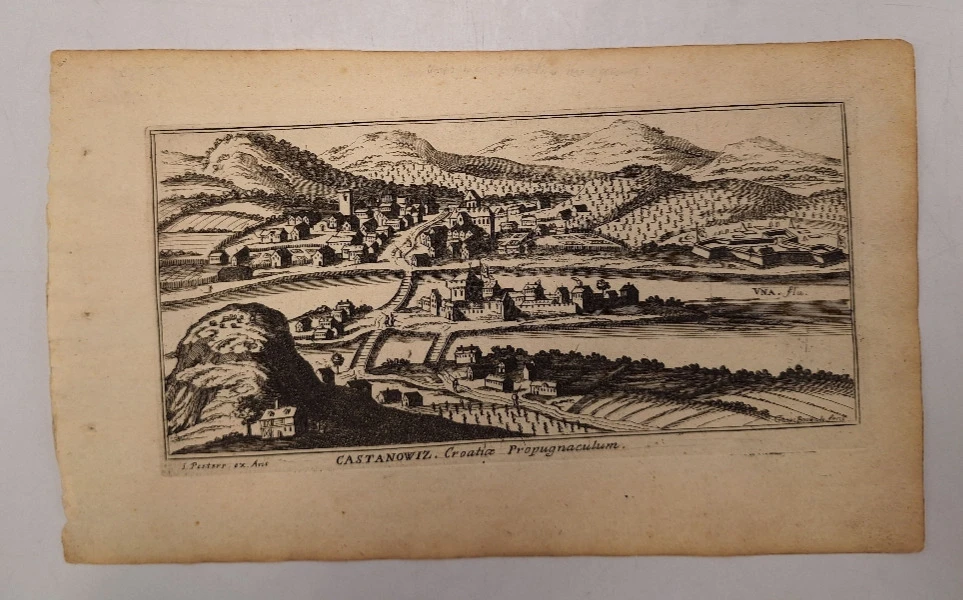
This veduta of Kostajnica is based on the identical veduta of Hoefnagel, which was published in Braun-Hogenberg's "Civitates Orbis Terrarum" in 1617. Veduta shows Kostajnica, specifically its Croatian part (today Hrvatska Kostajnica) and its part in Bosnia (today Bosanska Kostajnica) during the time when it was under Turkish rule. Namely, at the time of creation of this veduta, Kostajnica was a key Turkish fortress guarding the northwestern entrance to Bosnia. Due to the exceptional strategic importance of Kostajnica, Habsburg military topographers secretly sketched Kostajnica and its immediate surroundings. On the view, we can see the Kostajnica settlement, which consisted of three units: on the right side of the Una is the largest part of the settlement, where the center of the Turkish town (today Bosanska Kostajnica) was located. A wooden bridge connected the old part of the city with the river island with the fortress and the part of Kostajnica on the left bank of the Una (today Hrvatska Kostajnica) across the river Una. The title of the map is below the bottom edge of the map.
PEETERS, JACQUES (JACOBUS) (1637-1695) - publisher and copper-engraver who worked in Antwerp during the 17th century. The most famous work of Peeters is "L' Atlas en abrége", which has seen several editions.
Additional information
- Author: Peeters Jacques
- Publisher: -
- Year of publication:1686
- Place of publication:Belgija
- Pages:1
- Dimensions:30x18.5 cm
- Script:Latinica
- Condition:Odlično
- Binding:Meki
You may also like


Biblos Newsletter
For book lovers who enjoy finding the rare
New titles, special copies and quiet recommendations from the antiquarian bookshop.