Summary
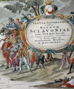
JOHANN BAPTIST HOMANN: Tabula geographica exhibens Regnum Slavoniae sum Sirmii Ducatu. Ex mappa grandiori desumta et in lucem edita ab Homannianis Heredibus-Map of Slavonia and Srijem Voivodeship
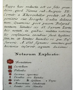
The map shows Slavonia and Srijem after the peace of Požarevac concluded in 1718, which freed Srijem from Turkish rule. As stated in the index, it was created on the basis of Khevenhuller's large demarcation map after the Peace of Požarevac and Gade's map of Slavonia from 1718. The map is particularly interesting because it shows the Slavonic possessions established after liberation from the Turks. The Slavonic part of the Military Territory is marked in green. The narrow strip south of the Sava, which was annexed to the Habsburg Monarchy by the Peace of Požareva, is also specially marked. The name of the map is in the upper right corner in a baroque cartouche containing the coat of arms of Bosnia, next to which Baron Trenk and his hussars are drawn. The map is in excellent condition.
Johann Baptist Homann (1663-1724) is an important German cartographer and publisher who engraved more than 600 maps in the period from 1702 to 1716. Homann maps are difficult to date precisely because they rarely bear the year of issue. His most famous works are: "Atlas Novus" from 1707, "Atlas von hundert Chartewon" from 1712 and "Grosser Atlas uber die ganze Welt" with 126 maps. After his death, his workshop was run by Michael Franz and Johann Georg Ebersberer under the name Homannianos Heredes (Heirs of Homann) until the beginning of the 19th century.
Biblos Newsletter
New titles, special copies and quiet recommendations from the antiquarian bookshop.