Summary
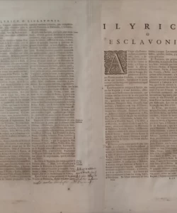
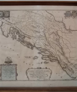
Ivan Lučić, Johannes Blaeu: Illyricum Hodiernum (Map of Illyria)
the map is framed between two glasses
The author of this map is the Croatian historian Ivan Lučić, the founder of Croatian historiography.
For his most famous work »On the Kingdom of Dalmatia and Croatia» (De Regno Dalmatiae et Croatiae libri sex)) which was published In 1668 in Amsterdam with the Dutch cartographer and publisher Johannes Bleau, Lučić made six historical maps of Croatian countries.
Although Lučić did not personally draw his maps, he is the author of their content.
Namely, the maps were drawn by Bleau, but based on Lučić's data. The last and most important among them was «, which shows Illyricum within the boundaries established by the ecclesiastical court in Rome in 1653, when it was decided that the term Illyricum included Dalmatia, Croatia, Slavonia and Bosnia, while Carinthia, Carniola and Styria were excluded from that circle. This map is best known for its dedication to Ban Petar Zrinski. The coats of arms of Bosnia, Slavonia, Dalmatia and Croatia are drawn along the upper edge of the map. The title of the map is in the lower left corner, while the dedication to Zrinski signed by Blaeu is located along the central part of the lower edge.
IVAN LUČIĆ, JOHANNES BLAEU – MAP OF ILLYRIKA
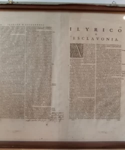
Illiricum Hodiernum, Quod Scriptores communiter Slcavoniam, Itali Schiavoniam nuncupare solent, in Dalmatiam, Croatiam, Bosniam et Slavoniam distingitur. Sed cum ejus majorem partem Turcae obti - neant, in Praefecturas eorum more Sanzacatus dictas divisum est, requum autem, Venti, Vngari, et Ragusini tenent. Sanzacatus sunt Bosnia, Residentia Bassae:; Poxega; Cernik; Bihak; Lika et Crbava; Clissa; Herzegovina.
Ivan Lučić, Johannes Bleau
The map of Illyricum shows the area between the Drava River and the Adriatic Sea, and on it are marked the historical borders of the Croatian countries - Croatia, Slavonia and Dalmatia, as well as the borders of medieval Bosnia. Next to them, on the territory under Turkish rule, the borders of Turkish administrative units - sandžakats were drawn.
IVAN LUČIĆ (1604-1679), historian, is one of the founders of Croatian historiography. A native of Trogir, he spent most of his life in Rome, in the Institute of St. Jerome. This is where his most famous work "On the Kingdom of Dalmatia and Croatia" (De Regno Dalmatiae et Croatiaelibri sex) was written, which was published in 1668 by the famous Dutch cartographer Johannes Blaue. For this work, Lučić prepared six historical maps of Croatian countries, among which the most famous is the sixth one entitled "Illyricum" with a dedication to the Croatian Ban Petar Zrinski. Lučić made his maps using numerous cartographic templates from which he took the physical-geographical basis, while he drew the historical-geographic content himself based on ancient and medieval sources that he used to create his historical maps.
Biblos Newsletter
New titles, special copies and quiet recommendations from the antiquarian bookshop.