

Cantelli da Vignolla Giacomo: La Croatia e Contea di Zara/descritte da Giacomo Cantelli da Vignola
€ 700,00
Free delivery in Croatia for orders over EUR 70
Basic information
- Author: Cantelli da Vignolla Giacomo
- Publisher: -
- Availability: Available
- Condition: Odlično
- Code: 13921
Shipping options
GLS Croatia
5€
Delivery
0€
Personal collection at the antique store
0€
GLS parcel machine
3€
Payment methods
Pay on pickup
CorvusPay
By general payment / Virman / Internet banking
Cash on delivery
La Croatia e Contea di Zara/descritte da Giacomo Cantelli da Vignola
Cantelli da Vignolla Giacomo
Summary
La Croatia e Contea di Zara/descritte da Giacomo Cantelli da Vignola
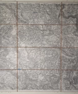
This map by Cantelli was published in his atlas "Mercurio Geografico" which was published in Rome in 1692. The map of Croatia and the Zadar area shows Croatia south of the Sava with the coast to the Krka river. The historical borders of Croatia towards Bosnia along the Vrbas River and the borders of Dalmatia towards Bosnia and Croatia are drawn. In the foreground is a depiction of the Zadar area, as the central part of Venetian Dalmatia, in whose hinterland at the time this map was made, part of the battles of the Moravian War, which was fought between the Republic of Venice and the Ottoman Empire until 1699, took place. The relief is shown with shaded molehills. "Monte Velebik" (Velebit), "Plessiuitza Mons" (Plješiivica), "Viszibaba" (Visibaba), "Petra Klek" (Klek) and "Zrinska Planina" (Zrinska gora) stand out. The river network is drawn quite faithfully. An exception is represented by the Lika and Gacka rivers, which, according to Cantelli, flow into the sea near Karlobag. The title of the map is in the upper left corner in the vegetation cartouche. It is interesting that the standard is expressed in Croatian miles (Miglia di Croatia) in addition to Italian, German and French miles. Cantelli took that measure from the famous map of Croatia by Stjepan Glavač from 1673.
Giacomo Cantelli da Vignola (Montorsello 1643 – Modena 1695). He studied in the cartographic workshop of Nicole Sanson. After returning to Rome, he got a job at the publisher De Rossi. He has been in Croatia several times filming forts and castles. He is the author of several vedutas (Osijeka, Virovitice, Knin) and panoramic maps of Lika and Krbava (Rome 1686). For the atlas of the Balkan countries Mercurio geografico (Rome 1692) he made three maps showing what was then Venetian Dalmatia, Croatia proper and part of western Slavonia. In 1685, he was appointed cartographer of Francesco II for his successful cartographic work. of Modena.
Additional information
- Author: Cantelli da Vignolla Giacomo
- Publisher: -
- Year of publication:1692
- Place of publication:Rim
- Dimensions:75x60 cm
- Script:Latinica
- Condition:Odlično
- Binding:Meki
You may also like


Recently viewed


Biblos Newsletter
For book lovers who enjoy finding the rare
New titles, special copies and quiet recommendations from the antiquarian bookshop.