Summary
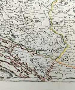
Nicolas Sanson: Partie Méridionale du Rme. de Hongrie / Map Croatia, Slavonia, Bosnia
Copper engraving of colored borders
The map shows the area of the southern part of Hungary, which extends all the way to the Sava River and includes all of Zagorje, Slavonia and Zagreb. Croatia includes the area south of the Sava, all the way to the sea, but only from Žrnovice to Obrovac, while the islands and coast from Nin to Šibenik are part of Venetian Dalmatia. The map shows indications of relief, still in the shape of a molehill, but the interesting feature of the map is the specially marked areas of forests, most of which are in Slavonia and along the north bank of the Drava.
Nicolas Sanson (1600 – 1667), French cartographer and founder of the Paris school of cartography that assumed primacy at the expense of Belgium and the Netherlands.
He was born in the old Picardy family of Scottish origin, and was educated by the Jesuits in Amiens. He started his cartographic career very early, at only 18 years old when he made a map of Gaul, which earned him the favor of Cardinal Richelieu, and then of the French royal court. He taught geography lessons to Louis XIII and Louis XIV, and the fact that Louis XIII. during his visit to Abberville, he preferred to stay with Sanson on the fortifications than in the royal chambers. During one of these meetings, the king appointed Sanson as a state councillor.
He began to engage more actively in cartographic publishing in 1627, when a more refined Galilee antiquae descriptio geographica was published, and in 1632, in collaboration with the engraver M. Tavernier, he also published Carte géographique des postes qui traversent la France. After he published several atlases, he began to actively cooperate with the publisher P. Mariette. In 1674, he accused the Jesuit P. Labbe of plagiarism because his Pharus Galliae Antiquae (1644) was similar to Sanson's older map of Gaul. A year later, he lost his eldest son, Nicolas, who was killed in the war against the Spanish. He died on July 7, 1667 in Paris, and his sons Adrien and Guillaume succeeded him as the geographer of the royal court.
Due to his great cartographic contributions and collaboration with the royal court, Sansona is often called the "founder" of French cartography, which is not entirely true because during the 16th century several notable names worked in Dieppe such as P. Desceliers, G. Le Testu and G. Brouscona.


Biblos Newsletter
New titles, special copies and quiet recommendations from the antiquarian bookshop.