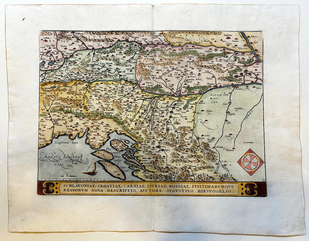

Hirschvogel Augustin: Schlavoniae, Croatiae, Carniae, Histriae, Bosniae finitimarumque regionum nova descriptio-Zemljovid Slavonije, Hrvatske, Kranjske, Istre i Bosne
€ 550,00
Free delivery in Croatia for orders over EUR 70
Basic information
- Author: Hirschvogel Augustin
- Publisher: -
- Availability: Available
- Condition: Odlično
- Code: 11716
Shipping options
GLS Croatia
5€
Delivery
0€
Personal collection at the antique store
0€
GLS parcel machine
3€
Payment methods
Pay on pickup
CorvusPay
By general payment / Virman / Internet banking
Cash on delivery
Schlavoniae, Croatiae, Carniae, Histriae, Bosniae finitimarumque regionum nova descriptio-Zemljovid Slavonije, Hrvatske, Kranjske, Istre i Bosne
Hirschvogel Augustin
Summary
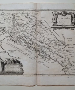
Augustin Hirschvogel: Map of Slavonia, Croatia, Carnia, Istria and Bosnia / Schlavoniae, Croatiae, Carniae, Histriae, Bosniae finitimarumque regionum nova descript
Hirschvogel's map of Croatia, Slavonia, Carniola, Istria and Bosnia is one of the most published maps of Croatian countries in the 16th and early 17th centuries. In the 1670s and 1680s, it was published in several editions of Ortelius's "Theatrum", and Gerhard Mercator included it in his atlas. This is her edition from Otrelius' atlas published in 1595. The map shows medieval Croatia and Slavonia with neighboring regions. For Hirschvogel, the area of Bosnia that was already part of the Ottoman Empire was "terra incognita". The relief is presented only partially using the molehill method, while the forests in the area of Slavonia, Podravina, Lika, Krbava and Gorski kotar are marked with a tree symbol. It is interesting that the entire Zagreb area is marked as extremely forested. The medieval fortress Medvedgrad is also marked above Zagreb. The title of the map is located along the lower edge of the map in a long rectangular renaissance map. In the lower left corner there is a graphic scale expressed in miles (Scala Milliariam).
ABRAHAM ORTELIUS (1527-1598) from Antwerp is the most famous representative of Dutch-Belgian cartography. After studying engraving and cartography, he started illustrating. However, he himself worked relatively little on mapping. Today, only five maps can be confidently claimed to have been created by Ortelius himself. Ortelius was primarily a map collector and publisher. So by 1570, he collected 70 maps, which he combined in the book "Theatrum Orbis Terrarum", the first atlas in today's sense of the word. However, the maps that the atlas contained came from other cartographers or were created by Ortelius, but according to someone else's template. On each map, Ortelius mentions the author of the map or the source on the basis of which he compiled the map. In addition to the maps, "Theatrum" also contains "Catalogum Auctorum" - a list of known cartographers (87 names) and their works. Ortelius' atlas aroused the same interest as Ptolemy's Geography. "Theatrum Orbis Terrarum" saw a total of 41 editions. How much fame the atlas brought to Ortelius is best shown by the fact that in 1575 the Spanish King Philip II declared him his royal cartographer. Similar to Ptolemy's work, the "Theatrum" began to be supplemented over time with new maps ("Additamenta").
Additional information
- Author: Hirschvogel Augustin
- Publisher: -
- Year of publication:1595
- Place of publication:Antwerpen
- Dimensions:55x42 cm
- Script:Latinica
- Condition:Odlično
- Binding:Meki
You may also like


Recently viewed

Biblos Newsletter
For book lovers who enjoy finding the rare
New titles, special copies and quiet recommendations from the antiquarian bookshop.