


Sažetak
Erhardo Reusch: Alter und Neuer Staat des Konigreichs Dalmatien I-II
obje knjige su uvezane zajedno
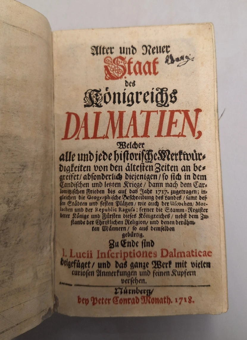
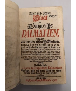
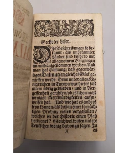
Alter und Neuer Staat des Königreichs Dalmatien, Welcher alle und jede historische Merkwürdigkeiten von den ältesten Zeiten an begreifet, absonderlich diejenigen, so sich in dem Candischen und letzten Kriege, dann nach dem Carlowitzischen Frieden bis auf das Jahr 1717 zugetragen; ingleichen die Geographische Beschreibung des Landes, samt dessen Städten und festen Plätzen, wie auch der Uscochen, Morlachen und der Republic Ragusa: ferner die Stamm-Register derer Könoge und Fürsten dieses Königreiches, nebst dem Zustande der Christlichen Religion, und denen berühmten Männern, so aus demselben gebürtig. Zu Ende sind I. Lucii Inscriptiones Dalmaticae beigefüget und das Werk mit vielen curiosen Anmerkungen und feinen Kupfern versehen
"Stara i nova uprava Kraljevine Dalmacije"
S opisom svih povijesnih događaja od najstarijih vremena, a posebno onih koji su se dogodili tijekom Kandijskog i posljednjeg rata i nakon Karlovačkog mira do 1717. godine, s geografskim opisom zemlje i njezinih gradova i utvrda, kako Uskoka/Morlaka tako i Dubrovačke Republike; te s rodoslovljem kraljeva i knezova ove Kraljevine, prikazom položaja kršćanske religije i predstavljanjem slavnih osoba rodom iz tih krajeva.
Doslovni prijevod naslova: "Stara i nova država Kraljevine Dalmacije".
Na knjigoveškom listu popis tabli s ilustracijama.
Poglavlje "Dalmatische Inscriptiones" počinje na str., 496 druge knjige ., i preuzeto je iz knjige hrvatskoga povjesničara Ivana Lučića "Inscriptones Dalmaticae...", tiskane u Veneciji 1673.
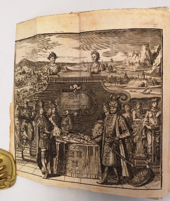
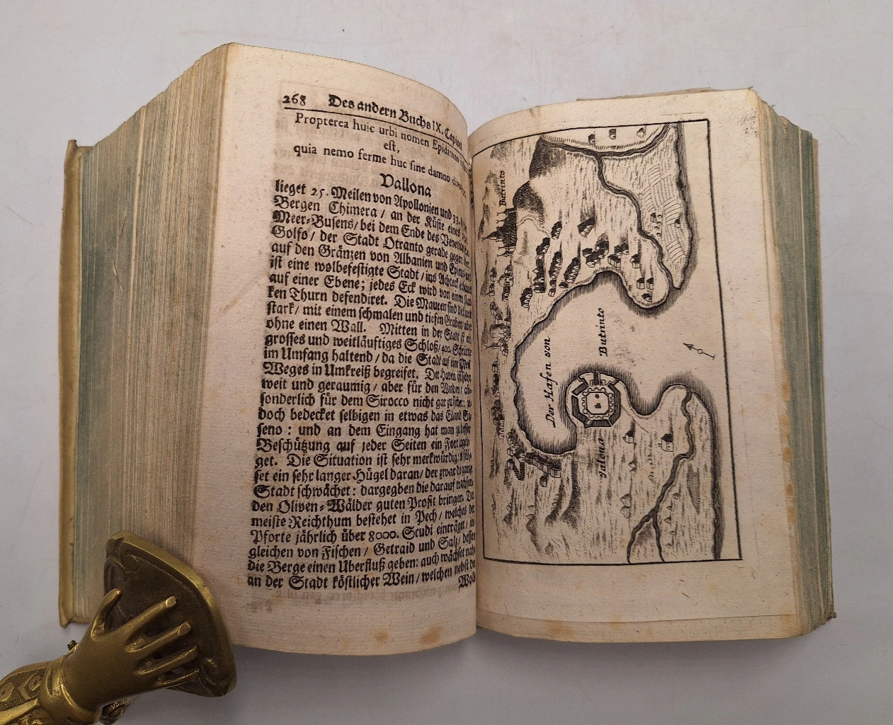
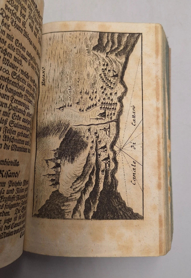
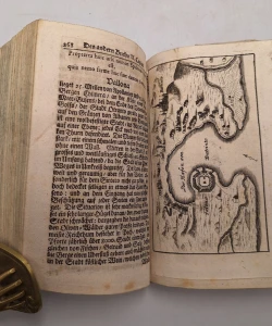
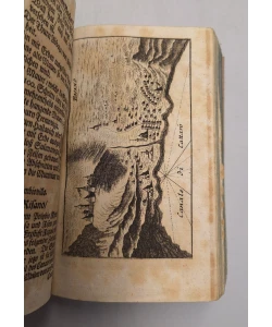
Ove su vedute gradova i utvrda mletačke Dalmacije objavljene u djelu Reucha Erharda «Alter und neuen Staat des Königreichs Dalmatien» izdatom u Nürnbergu kod njemačkog izdavača Johanna Kaspara Monatha 1718. godine. U svojem djelu Reusch objavljuje vedute hrvatskih gradova i utvrda, na obali : Rijeke (S. Veith am Pflavm oder Fiume), otoka Raba (Insul Arbe), otoka Paga (In. Pago), grada Osora na otoku Cresu (Osera), Senja (Zeng), Knina (Chnin), Vrane (Urania), Karina (Carin), Nadina (Nadin), Drniša (Dernis), Zemunika (Zemonico), Zadra (Zara), Šibenika s okolicom (Sebenico), Skradina i Prokljanskog jezera (Scardona, Lago di Prochlian), Trogira (Citta di Trau), Klisa (Clissa), Splita (Spalatro), otoka Hvara (Liesina Ins.), Makarske (Macarsca), otoka Korčule (Curzola), Sinja (Sing), Zadvarja s okolicom (die Landschaft Duare), Opuzena (Opus) i Dubrovnika (Ragusa). U djelu nalazimo i vedutu vojnokrajiške utvrde Otočca (Ottozitz) koji se u vrijeme nastanka ove karte nalazi u sastavu Vojne Krajine, točnije Karlovačkog generalata. Južno od Dubrovnika koji je također pripadao pokrajni mletačke Dalmacije, zastupljene su vedute Bokokotorskog zaljeva, Risana (Risano), Herceg-Novog (Castelnuovo), Budve (Budova) i Ulcinja (Dulzigno) koji se danas nalaze na teritoriju Crne Gore te vedute Drača (Durazo) i Skadra (Scutari) tada također dijela mletačke Dalmacije, a danas u sastavu Albanije. Sve navedene vedute preuzete su s predložaka iz djela mletačkog kartografa Vincenza Marie Coronellija “Isolario dell Atlante Veneto” te djela slovenskog polihistora Janeza Vajkarda Valvasora «Die Erde des Hertzoghums Crain» (U slavu vojvodine Kranjske).
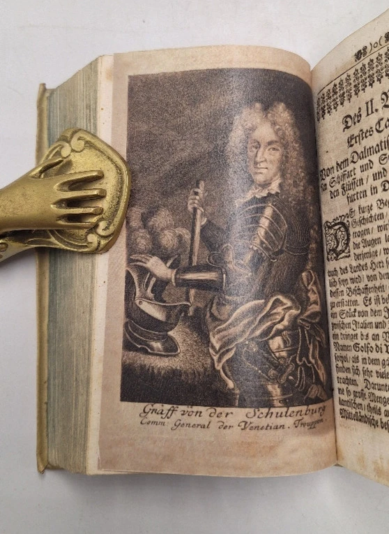
Monathov zemljovid na kraju knjige i litografija gfa Von der Schunterberga na početku druge knjige su faksimili
both books are bound together
"Old and new administration of the Kingdom of Dalmatia"
With a description of all historical events from the earliest times, especially those that occurred during the Candian and last wars and after the Peace of Karlovac until 1717., with a geographical description of the country and its cities and forts, both in Uskok/Morlak and in the Republic of Dubrovnik; and with the genealogy of the kings and princes of this Kingdom, the presentation of the position of the Christian religion and the presentation of famous persons born from those regions.
Literal translation of the title: "Old and new state of the Kingdom of Dalmatia".
On the binder sheet, a list of tables with illustrations.
The chapter "Dalmatische Inscriptiones" begins on page 496 of the second book ., and is taken from the Croatian historian Ivan Lučić's book "Inscriptones Dalmaticae...", printed in Venice in 1673.
These views of the cities and fortresses of Venetian Dalmatia were published in Reuch Erhard's work «Alter und neuen Staat des Königreichs Dalmatien» published in Nuremberg by the German publisher Johann Kaspar Monath in 1718. In his work, Reusch publishes views of Croatian cities and forts, on the coast: Rijeka (S. Veith am Pflavm oder Fiume), the island of Rab (Insul Arbe), the island of Pag (In. Pago), the town of Osor on the island of Cres (Osera), Senj (Zeng), Knin (Chnin), Vrana (Urania), Karina (Carin), Nadina (Nadin), Drniša (Dernis), Zemunik (Zemonico), Zadar (Zara), Šibenik and its surroundings (Sebenico), Skradin and Lake Prokljan (Scardona, Lago di Prochlian), Trogir (Citta di Trau), Klis (Clissa), Split (Spalatro), the island of Hvar (Liesina Ins.), Makarska (Macarsca), the island of Korčula (Curzola), Sinj (Sing), Zadvar and its surroundings (die Landschaft Duare), Opuzen (Opus) and Dubrovnik (Ragusa). In the work, we also find a view of the military fortress of Otočac (Ottozitz), which at the time of the creation of this map was part of the Military Krajina, more precisely the Karlovac Generalate. South of Dubrovnik, which also belonged to the province of Venetian Dalmatia, there are views of the Boko Kotor Bay, Risano (Risano), Herceg-Novi (Castelnuovo), Budva (Budova) and Ulcinj (Dulzigno), which today are located on the territory of Montenegro, and the views of Durres (Durazo) and Shkodër (Scutari) were then also part of Venetian Dalmatia, and today are part of Albania. All the above views are taken from templates from the work of the Venetian cartographer Vincenzo Maria Coronelli "Isolario dell Atlante Veneto" and the work of Slovenian polyhistorian Janez Vajkard Valvasor "Die Erde des Hertzoghums Crain" (In glory of the Duchy of Carniola).
Monath's map at the end of the book and gfa Von der Schunterberg's lithograph at the beginning of the second book are facsimiles
Publisher: Peter Conrad Monath
Place of publication: Nuremberg
Year of publication: 1718
Number of pages: 398+ 562 +40
Dimensions: 10x17.5cm
Binding: Hard
Condition: Very good
Key words: Dalmatia, Kingdom of Dalmatia, old Croatian history


Biblos Newsletter
Novi naslovi, posebni primjerci i tihe preporuke iz antikvarijata.